Maps of Physical Regions
 China: climatic regions. [Map/Still]. In Britannica Online for Kids. Retrieved from http://kids.britannica.com/comptons/art-137856
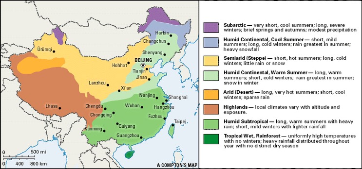
The image above shows the climate regions of China.

(2014). Natural Vegitation [Web Photo]. Retrieved from http://maps.howstuffworks.com/china-natural-vegetation-map.htm
The image above is a map of the natural vegetation in China.
Maps Showing Cultural Regions

U.S Central Inteligence Agency (Producer). (2010, December 04). Ethnolinguistic Groups of China [Web Map]. Retrieved from http://en.wikipedia.org/wiki/File:Ethnolinguistic_map_of_China_1983.png
The image above is a map that shows the Ethnolinguistic groups in China.
Images of Landscape

China Tour. (Photographer). (2013). Longsheng Rice Terrace [Print Photo]. Retrieved from http://www.chinatour.com/china-attractions/longsheng-rice-terrace.htm
The image above is of the Longsheng rice terraces near Guilin, China. This is an example of human landscape. People had cut into the mountain sides to form terraces to grow rice.

Fischer, P. (Photographer). (2011, December 31). New Year Night Pudong [Print Photo]. Retrieved from http://commons.wikimedia.org/wiki/File:2012_New_Year_Night_Pudong.jpg
The image above is of the evening skyline of Shanghai. Shanghai had a 23.47 million people in 2012 and is the financial center of China. This is an example of the human landscape in China.

Dishio (Photographer). (2008, October 19). Wuzhen General View [Print Photo]. Retrieved from http://commons.wikimedia.org/wiki/File:Wuzhen_general_view.jpg
The above image is of the Wuhzen watertown. This is a human landscape. It was built 1,300 years ago on the banks of the Grand Canal. People use boats to navigate through the town.

(2004, October ). Desert-Inner Mongolia [Web Photo]. Retrieved from http://commons.wikimedia.org/wiki/File:Desert_-_Inner_Mongolia.JPG
The above image is of the Gobi desert in China. This is a physical landscape. The Gobi desert runs through China and Mongolia.

King, C. (Photographer). (2007, August 05). Huangshan [Web Photo]. Retrieved from http://commons.wikimedia.org/wiki/File:Huangshan_pic_4.jpg
The physical landscape above is of the Huangshan or Yellow Mountain. Its beauty is famous. It has been described in Chinese poems and literature. It is a huge tourist attraction.
